Plant succession and the oldest primary succession plots in the world.
“The phenomena of nature are fluent [sic], not rigid, and no set of pigeonholes will entirely contain them.”
Note: This page is being updated - after a second trip to the archives the complete set of photos and stem maps have been collected, as well as substantial other data on historical land cover, bird and mammals through succession, and other quantitative and qualitative data. As it gets processed it'll get posted, email me for more info: bbuma at alaska.edu
Current known pictures of the permanent plot network. Click on image to see entire range (1916 - 2016). Higher resolution available upon request, brian.buma@ucdenver.edu.
100 years ago, William s. cooper founded what is now believed to be the longest running primary succession plot network in the world
William S. Cooper, one of the founding fathers of ecology, is known for many things - presiding over the Ecological Society of America, inspiring one of the most impressive academic family trees in the biological sciences, being a founding father of Glacier Bay National Park. One of his largest contributions to the science of ecology was foundational work on plant succession, inspired in part by his adviser, Cowles, who similarly studied the phenomena of community development with time.
Cooper, in a moment of inspiration, seized upon the opportunity provided by Glacier Bay to establish a network of permanently marked plots on recently deglaciated rock, areas recently devoid of plant life. He had the intention to revisit and chart the development of the plant community from early mosses to gigantic late successional trees in real time. Cooper realized that while chronosequences (studying different locations which are different ages) are useful for inferring change through time, they are less informative then actually observing change through time. He also had the foresight to understand this was a multi-lifetime project, and provided extensive directions to the plots with the express intention of future researchers not yet born continuing the work. Unfortunately, the plots languished after the death of Cooper in the 1970's and his graduate student, Donald Lawrence, in the early 1990's. A combination of isostatic rebound, magnetic declination changes, vegetation change, soil buildup covering the corner markers, and the lack of GPS coordinates (how we rely on them now!) meant the locations were lost.
Shots of "Cross Rock," an important navigational tool. All pictures from same perspective. The 2017 image is taken from almost the identical spot as the 1967 image, though the rock is completely obscured.
Location of plots and a nice comparison of landscape development. A and B both taken from the same location, A in approximately 1941, B in 2016. Point is near Q2 on the map.
100 years later...
In 2016, I led an expedition (sponsored by National Geographic and the University of Alaska) to rediscover those plots amongst the now developing woody plant community, bears, and wolves. Using a combination of 1916 maps from the University of Minnesota archives, metal detectors, and compasses (and a variety of other shoestring-type techniques) we found and remeasured the plots, which show substantial change over the last century. By GPS'ing these locations any interested researcher can now access 100 years of permanent plot data, including community composition, maps, diversity indices, and a variety of ancillary data for powerful questions about how communities change, the role of stochastic variability, and rates of change in response to climate warming.
Community development has proceeded in some ways according to theoretical expectations, but in other ways it has diverged from expected timelines. In general, the data highlights the importance of contingency, or random variation in what species established first. The primary player here are willows - if there were willows establishing 100 years ago, they are still around. They form thick nests about 2 meters high, too dense for much tree establishment (the absolute number of willows has decreased as individuals have gotten bigger). In other areas, where competition with mat forming herbs appeared to keep out the willows, there are alders, spruce, and other later successional species.
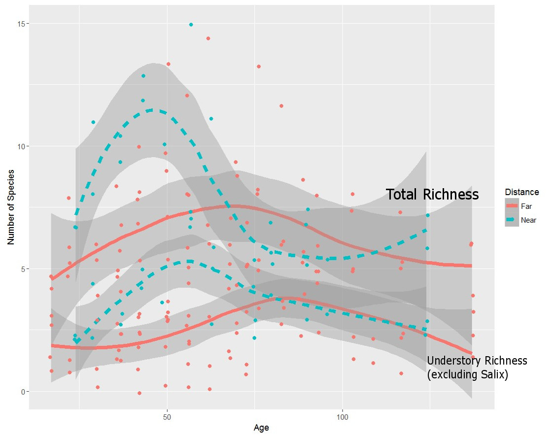
Time since glaciation compared to species richness over 8 study sites and 100 years (approximately 8-12 observations per site). There is a pulse of high species richness apparent across all plots early, about 50 years after glacial recession, followed by a decline as a few species take over (generally Salix spp) and understory diversity declines. Other metrics of community diversity being calculated currently (Oct 2017).
soil development
Diversity
While richness has gone up overall, meaning more species, the communities are increasingly being dominated by a few number of species - willows or spruce. The small size of the plots established by Cooper means further work is needed to accurately estimate overall diversity, but the patterns in relative diversity are likely real given the data.
Two diversity metrics - Effective number of species and Hurlbert's probability of interspecific encounters. Both decline with time, a result of a small number of species taking over. Despite increasing richness, the majority of plots are now covered by the same species, so effective diversity seems lower. Date for middle years being worked up currently.
Soil development appears to reflect species change and community development - meaning unlike expectations of orderly increase in soil depth, nitrogen and carbon content, etc, we see strong legacies of stochastic species arrival community assemblage. This suggests that on the century timescale, as glaciers recede and as plants push into high latitudes, soil development may be highly heterogeneous.
Soil characteristics as a function of plot location relative to the community source populations (near or far) and age of plots. "Near" plots are closer to the entrance to Glacier Bay, and have generally had faster community development.
The latest effort is aimed at expanding Cooper's plots to reflect the reality of a more "mature" (term used loosely!) forest. One m2 plots are not an appropriate size for a more structurally complex forests, with larger individuals, and in 2017 I led another group to put in 15m radius plots around each of the original plots. In those plots, we cored trees, placed 10 additional quadrats, and are looking at community development, yes, but also beta diversity, alpha diversity estimates, and microbial/fungal dynamics - all within a strict, spatially explicit design that will allow us also to explore spatial autocorrelation in these environments. This gets to a fundamental question - how representative are these plots?
See Buma et al. 2017 for the initial results, the 2017 expedition is in review.

Dr. Sarah Bisbing sits on Arrow Rock, one of the key navigational points from 1916. Comparative images from 1926 (top right) and 1941 (likely) are shown. Interesting factoid - the modern 2016 picture has >3000 people in it. Look close and you can see a cruise ship in the background, a very different reality from what Cooper found in 1916. Also, note how different the alluvial fan in the background is. The photos are from the same location, but in 1926 the fan was much, much smaller (and in 1941). That isn't tidal. It's a combination of the fan growing (it's quite shallow right off the edge, makes for some interesting kayaking) and isostatic rebound, which is very rapid in this portion of the bay.
Thanks to Sarah Bisbing (Cal Poly), John Krapek (UAF), Glenn Wright (UAS), and Glacier Bay National Park for making the re-discovery expedition successful, and Allison Bidlack and Greg Wiles for working on the 2017 expedition.